Overnight: Patchy fog. Otherwise, mostly cloudy, with a low around 58. Calm wind.
Tuesday: A 50 percent chance of showers after 1pm. Mostly cloudy, with a high near 64. Calm wind becoming northeast around 5 mph.
Tuesday Night: Rain. Low around 56. East northeast wind around 5 mph. Chance of precipitation is 100%.
Forecast Courtesy of NWS.
Showing posts with label Forecast. Show all posts
Showing posts with label Forecast. Show all posts
Tuesday, October 13, 2009

Monday, October 12, 2009
More Rain and Cold
As you can see by checking out the latest seven day below from NewsChannel 5 Weather, a rainy and cool week is in store for all of Middle Tennessee. A frost saturday night/sunday morning is quite possible for the mid-state as much cooler weather embraces the area.

Monday, October 5, 2009
Storms Return Thursday
Tonight: Mostly cloudy, with a low around 58. Southeast wind around 5 mph.
Tuesday: A 40 percent chance of showers and thunderstorms after 1pm. Mostly cloudy, with a high near 72. South wind between 5 and 10 mph.
Tuesday Night: Showers and thunderstorms. Low around 54. South southwest wind around 10 mph becoming northwest. Chance of precipitation is 80%.
Forecast Courtesy of National Weather Service.
Tuesday: A 40 percent chance of showers and thunderstorms after 1pm. Mostly cloudy, with a high near 72. South wind between 5 and 10 mph.
Tuesday Night: Showers and thunderstorms. Low around 54. South southwest wind around 10 mph becoming northwest. Chance of precipitation is 80%.
Forecast Courtesy of National Weather Service.
Saturday, September 26, 2009
Winter Forecast

Crossville, Tenessee: Average Snowfall 7.7" Projected Snowfall 12"-17"
Dickson, Tennessee: Average Snowfall 5.4" Projected Snowfall 9"-13"
Lewisburg, Tennessee: Average Snowfall 3.2" Projected Snowfall 7"-11"
Monterey, Tennessee: Average Snowfall 20.5" Projected Snowfall 24"-28"
Nashville, Tennessee: Average Snowfall 8.3" Projected Snowfall 12"-16"
Pulaski, Tennessee: Average Snowfall 2.8" Projected Snowfall 7"-11"
Tullahoma, Tennessee: Average Snowfall 3.9" Projected Snowfall 8"-12"
Fall Like Forecast

A much more fall like forecast for late september. The above forecast from WTVF, shows a much dryer and cooler week ahead. It has been a while since we have seen a forecast for a week that included all 70's for highs and some 40's and 50's for lows. The leaf color should begin changing after this week. :)
Friday, September 25, 2009
Flash Flood Watch
THE NATIONAL WEATHER SERVICE IN NASHVILLE HAS ISSUED A * FLASH FLOOD WATCH FOR A PORTION OF MIDDLE TENNESSEE... INCLUDING THE FOLLOWING AREAS...BEDFORD...CANNON...CLAY... COFFEE...CUMBERLAND...DAVIDSON...DEKALB...FENTRESS...GILES... GRUNDY...HICKMAN...JACKSON...LAWRENCE...LEWIS...MACON... MARSHALL...MAURY...OVERTON...PERRY...PICKETT...PUTNAM... RUTHERFORD...SMITH...SUMNER...TROUSDALE...VAN BUREN...WARREN... WAYNE...WHITE...WILLIAMSON AND WILSON. * FROM LATE TONIGHT THROUGH SATURDAY AFTERNOON * SHOWERS AND THUNDERSTORMS ARE EXPECTED TO DEVELOP TONIGHT AND LAST INTO SATURDAY. BANDS OF RAINFALL COULD PRODUCE TWO INCHES OF RAINFALL. CONSIDERING THE RECENT RAINS EXPECT SOME FLOODING TO OCCUR.
Thursday, September 24, 2009
Warm and Wet Continues
Thursday Forecast...
More showers will continue on and off today across the Middle Tennessee valley. Highs today will range from the upper seventies to the lower eighties. Some of the showers today could bring some brief heavy rainfall. Though major flooding is not expected, isolated flash flooding can not be ruled out.
Friday-Sunday...
Warm and soggy conditions will remain across the area until Saturday. More heavy rain on Friday and Saturday could cause more isolated flash flooding, especially across western middle Tennessee. Temperatures will remain right around 80 for highs and lows dipping into the 60's,
Monday-Wednesday...
A cold front will finally begin to clear the air next week. Dryer cooler air will push south across the lower 48 bringing highs in the low 70's and lows in the low 50's. This will be the first real push of cooler air for the 2009 fall season.
Tuesday, September 22, 2009

Monday, September 21, 2009
More Rain Ushers in Fall
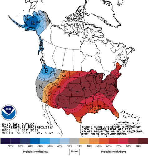
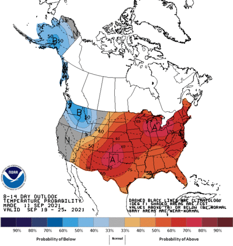
This is typically the driest time of the year. Autumn starts Tuesday and the midstate will continue to see warm soggy conditions. Rain chances will stick around until early next week when this system looks to finally move out of our area. Though that could change.
Sunday, September 13, 2009
Monday, August 10, 2009
Warm Monday

Most area's will see temperatures soar into the low 90's once again today. Temperatures however will likely stay a tad lower than what could be expected thanks to some afternoon cloudiness accompanied by a few showers and thunderstorms.
Tropical Invest 99L is still holding her own this morning. The NHC still gives this system between 30-50% of developing into a tropical syste m. However, even then, the chances of this system affecting the United States is rather low.
Sunday, August 9, 2009
Patchy Fog

A little patchy fog will be possible overnight into the early morning hours of Monday. The overnight fog will give way to a partly sunny sky on Monday with a few showers and thunderstorms possible. Better chances will come later in the week.
Showers Today

As moisture continues to increase across the basin today, a few scattered showers will be around today. The best chance today will be off to the east along the plateau.
Some tropical developments this afternoon as well. A tropical wave moving off the coast of Africa has a good potential to spin into a tropical storm and head eastward. I will continue to monitor this over the next few days.
-Photo courtesy of NWS
Saturday, August 8, 2009
Summer Like Weather Continues
As of the past few days, the middle Tennessee basin has fallen into a more summer like pattern than of late. Expect more of the same conditons over the next several days with only slight chances of some afternoon thunderstorms. Towards mid week temperatures will back off slightly as the chance of scattered thunderstorms increase.
No tropical weather currently expected across the Atlantic or Gulf.
No tropical weather currently expected across the Atlantic or Gulf.
Wednesday, July 8, 2009
Few Storms

A few thunderstorms are slowly drifting about across south central kentucky tonight. Doubtful that this activity will drift much further south tonight. Otherwise dry and warm this evening. The heat really begins to climb the remainder of the week with highs into the mid 90's. A chance of storms will be a bit better come this weekend.
Map Courtesy of NWS, Nashville
Warm and Dry

Warm and dry will be the general rule this week across Middle Tennessee. Highs today will approach 90 degrees across most locales. Tonight temperatures will drop back off into the mid 60's. A few isolated showers could develop today along our eastern most counties but are not expected to be widespread by any means. Enjoy the summer like weather as we are in the peak of summer and will soon be headed back towards cooler weather in just two brief months.
Tuesday, July 7, 2009
Forecast
This Afternoon: Sunny, with a high near 88. North wind around 5 mph.
Tonight: Mostly clear, with a low around 66. North wind between 5 and 10 mph becoming calm.
Courtesy of National Weather Service
Tonight: Mostly clear, with a low around 66. North wind between 5 and 10 mph becoming calm.
Courtesy of National Weather Service
Tuesday, June 30, 2009
Beautiful Today
 This Afternoon: Sunny, with a high near 90. Northwest wind between 10 and 15 mph, with gusts as high as 25 mph.
  Tonight: Mostly clear, with a low around 61. West northwest wind between 5 and 10 mph.


Forecast Courtesy of the National Weather Service, Nashville
Tuesday, March 31, 2009
Afternoon Forecast
This Afternoon: Showers and thunderstorms likely. Mostly cloudy, with a high near 63. South wind around 15 mph, with gusts as high as 25 mph. Chance of precipitation is 70%.
Tonight: Showers and thunderstorms likely before 1am, then a chance of showers. Cloudy, then gradually becoming partly cloudy, with a low around 44. South wind 5 to 10 mph becoming west northwest. Chance of precipitation is 70%.
Wednesday: Sunny, with a high near 66. Northeast wind around 5 mph.
Wednesday Night: Partly cloudy, with a low around 48. East wind around 5 mph.
Forecast Courtesy of The National Weather Service
Tonight: Showers and thunderstorms likely before 1am, then a chance of showers. Cloudy, then gradually becoming partly cloudy, with a low around 44. South wind 5 to 10 mph becoming west northwest. Chance of precipitation is 70%.
Wednesday: Sunny, with a high near 66. Northeast wind around 5 mph.
Wednesday Night: Partly cloudy, with a low around 48. East wind around 5 mph.
Forecast Courtesy of The National Weather Service
Monday, March 30, 2009
Afternoon Forecast
This Afternoon: Mostly sunny, with a high near 66. Southeast wind around 10 mph.
Tonight: Mostly cloudy, with a low around 45. Southeast wind between 5 and 10 mph.
Tuesday: A 50 percent chance of showers and thunderstorms. Mostly cloudy, with a high near 65. South southeast wind between 10 and 20 mph, with gusts as high as 30 mph.
Tuesday Night: Showers and thunderstorms, mainly before 1am. Low around 44. South wind 5 to 10 mph becoming northwest. Chance of precipitation is 80%.
Forecast is courtesy of the National Weather Service
Tonight: Mostly cloudy, with a low around 45. Southeast wind between 5 and 10 mph.
Tuesday: A 50 percent chance of showers and thunderstorms. Mostly cloudy, with a high near 65. South southeast wind between 10 and 20 mph, with gusts as high as 30 mph.
Tuesday Night: Showers and thunderstorms, mainly before 1am. Low around 44. South wind 5 to 10 mph becoming northwest. Chance of precipitation is 80%.
Forecast is courtesy of the National Weather Service
Subscribe to:
Posts (Atom)